Hw3 Atms120
Submitted by: Submitted by xhuang13
Views: 320
Words: 451
Pages: 2
Category: Science and Technology
Date Submitted: 02/15/2014 07:15 PM
Name and NetID: _________________________________________
Weekly Challenge Problem #3: Satellites and Radar Due: Tuesday Feb 18, 2014
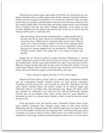
1. Examine the satellite images below and answer the questions that follow.
[pic][pic]
a. What satellite channel was used to make the image on the left?
Visible, Infrared or Water Vapor (circle one)
b. What satellite channel was used to make the image on the right?
Visible, Infrared or Water Vapor (circle one)
c. Which satellite image is best suited to view clouds 24 hours a day?
Left or Right.
d. Which satellite image is measuring the temperature of objects in its view?
Left or Right
e. Which satellite image uses albedo to distinguish objects within its field of view? Left or Right?
f. The same satellite took both of these images. What type of orbit was this satellite in that took these images?
g. Which two oceans can you see in these images?
h. Why is the western most edge of the right image dark?
i. These images were captured at 1145 UTC Sept 17, 2013. What time is that locally in Champaign?
To answer the series of questions given below, you will need to open the following file.
http://www.atmos.illinois.edu/~snodgrss/WCP-3.pdf
Questions on Slide #1
1. Focus on the radar sites that are highlighted by the three white arrows.
a. What “mode” of operation were these radars operating in when this national radar image was made?
b. What do meteorologists call the radar echoes that surround the radar but are not from precipitation?
c. What most likely caused these radar echoes?
Questions on Slide #2
2. The white line on both radar images indicates one edge of this squall line of thunderstorms. In which direction are these storms moving? (Please answer by writing, “they are moving from the...