Climatograph Analysis
Submitted by: Submitted by BANANABOY
Views: 390
Words: 424
Pages: 2
Category: Science and Technology
Date Submitted: 12/31/2010 11:31 AM
Climatographs
By Noor Jafri
Vancouver, BC
Latitude: 49°17'00.000" N
Longitude: 123°07'00.000" W
Elevation: 86.30 m
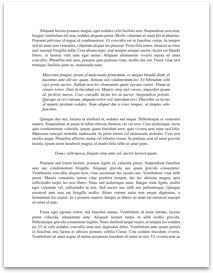
Average Monthly Temperature and Precipitation for Vancouver Harbors, British Columbia
[pic]
Analysis:
1. Vancouver gets a lot of precipitation especially at the starting and the end of the year. It is also very cold most of the year except for June and August.
2. Vancouver is a taiga. Taigas mostly consist of evergreen conifer trees and are also known as boreal forests. It usually gets around 40 to 100cm/year of precipitation and average annual temperature of 4°C to 14°C.
3. Taigas usually have cool summers and long, cold winter seasons with much snow. This is exactly what Vancouver gets except that it doesn’t get a lot of snow because it is near a huge body of water,
Toronto, ON
Latitude: 43°40'00.000" N
Longitude: 79°24'00.000" W
Elevation: 112.50 m
Average Monthly Temperature and Precipitation for Toronto, Ontario
|Months |Average Temperature (oC) |Average Precipitation (mm) |
|Jan |-4.2 |61.2 |
|Feb |-3.2 |50.5 |
|Mar |1.3 |66.1 |
|Apr |7.6 |69.6 |
|May |14.2 |73.3 |
|Jun |19.2 |71.5 |
|Jul |22.2 |67.5 |
|Aug |21.3 |79.6 |
|Sep |17 |83.4 |
|Oct |10.6...
More like this
- Climatograph Analysis
- Risk Analysis Investment
- Avon Case Study Analysis
- Gap Analysis
- Finance Analysis On Peacock
- Analysis Of Marketing Mix
- Organizational Analysis Of Riordan Manufacturing
- Cultural Analysis For Chicago Style Pizza
- Legal Analysis Of Freedom Of Expression
- Mba 500-Gap Analysis: Global Communications